


ANCIENT SHIPWRECK ON PAG, VLAŠKA MALA
DEPTH: 24 - 30 m
SKILL: Advanced
Merchant – sailing ship; unknown origin
Period: 1st century B.C.
Sunk: cause probably “bura” (strong NE wind)
Coordinates: 44.56910° N, 14.96203° E
Location: cove of Vlaška Mala, not far from the ferry quay of Žigljen, island of Pag
Access: 1/5 by boat, due to the inaccessibility of the rocky shore
Visibility: 4/5 very good, but sometimes poor
Current: 4/5 weak
Flora and fauna: 2/5 rather rare, single specimens
HISTORY:
The exact cause of the sinking of this small sized merchant ship with its cargo of amphorae for wine is unknown. The trade in wine in ancient times was very developed and the maritime trade routes went from the Mediterranean, along the entire eastern coast of the Adriatic right until their most northern point, from where the route continued over land to the furthest Roman settlements. In the period of ancient sailing ships, sailing took place only during times of the year when there were favourable weather conditions i.e. the end of May until mid-September, although sailing in the central Adriatic was sometimes practiced outside of this period, and did not completely cease even during the winter. The reason behind this was the inability of sailing upwind (because at that time the forward sail – jib was still unknown and only invented much later), as well as the weak manoeuvrability of the then ships, which were therefore very sensitive to sudden changes in the direction of the wind or to strong “bura” NE winds.
It is also possible that our merchant sailing ship became a victim of a sudden “bura” which in the Velebit Channel occasionally occurs during the summer months, creating large waves that prevent all sailing. With broken sails and no possible manoeuvrability, the unfortunate ship was carried by the “bura” and ended up on the bare, rocky coast of the island of Pag. Sharp rocks quickly ripped open its hull and the ship sank immediately along the shore, resting down on the sandy underwater slope. With time the wooden parts of the ship have rotted away and the contents of it cargo hold – ceramic amphorae, have remained on the bottom forming a small artificial mound, the only trace of the ancient shipwreck…
CONDITION OF THE LOCALITY AND DIVING:
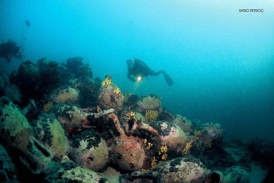
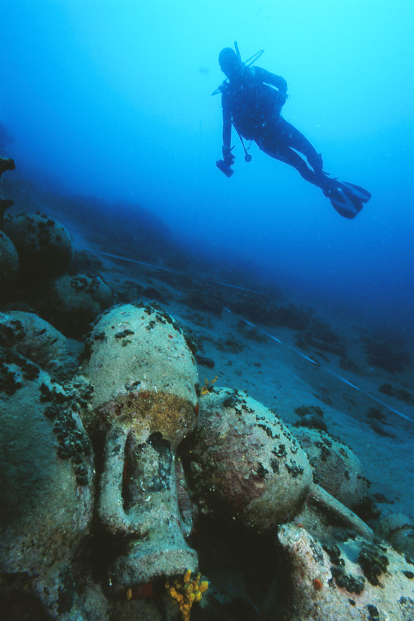
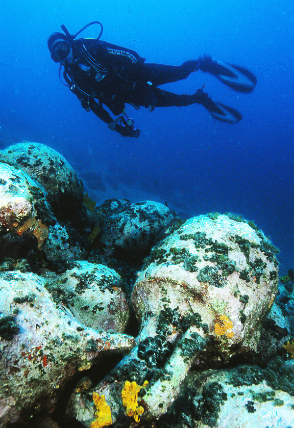
The site is situated along the northern cape of the cove of Vlaška Mala, which is located south of the ferry quay in Žigljen, which the local inhabitants also call “Zidić”. The remains of the shipwreck lie on a rocky–sandy slope of the seafloor, and extend to a depth of 24 to 30 metres. The main concentration of amphorae, measuring about 8 x 9 metres, consists of about one hundred intact or partly damaged examples which lie in several layers. In the immediate vicinity of the mentioned group, in the lower part of the site can also be seen two lead crossbars of ancient anchors. About 7 metres north of the site, in the direction of the shore, at a depth of 24 metres is situated a smaller group of four fused together amphorae. In the south-western part of the main concentration of amphorae can also be seen the lower part of a stone millstone which was a common component of ship equipment, used for grinding grain on long voyages.
All the visible amphorae belong to the Lamboglia 2 type. This is a late Roman Republic amphora intended primarily for the transport of wine, and which is frequently found in Croatian waters. They were produced in the 1st century B.C. in workshops along the western, and probably also along the eastern coasts of the Adriatic.
The complete site can be easily visited in one dive, and the very good visibility also makes it very attractive for photography. In 2004 the locality was entered onto the list of registered cultural assets and that same year it was covered with a protective net. Diving activities are permitted only through authorised diving centres.
The description and illustrations are a courtesy of Danijel Frka and Jasen Mesić. Buy the whole book here: https://shop.naklada-val.hr/product_info.php?products_id=561
Period: 1st century B.C.
Sunk: cause probably “bura” (strong NE wind)
Coordinates: 44.56910° N, 14.96203° E
Location: cove of Vlaška Mala, not far from the ferry quay of Žigljen, island of Pag
Access: 1/5 by boat, due to the inaccessibility of the rocky shore
Visibility: 4/5 very good, but sometimes poor
Current: 4/5 weak
Flora and fauna: 2/5 rather rare, single specimens
HISTORY:
The exact cause of the sinking of this small sized merchant ship with its cargo of amphorae for wine is unknown. The trade in wine in ancient times was very developed and the maritime trade routes went from the Mediterranean, along the entire eastern coast of the Adriatic right until their most northern point, from where the route continued over land to the furthest Roman settlements. In the period of ancient sailing ships, sailing took place only during times of the year when there were favourable weather conditions i.e. the end of May until mid-September, although sailing in the central Adriatic was sometimes practiced outside of this period, and did not completely cease even during the winter. The reason behind this was the inability of sailing upwind (because at that time the forward sail – jib was still unknown and only invented much later), as well as the weak manoeuvrability of the then ships, which were therefore very sensitive to sudden changes in the direction of the wind or to strong “bura” NE winds.
It is also possible that our merchant sailing ship became a victim of a sudden “bura” which in the Velebit Channel occasionally occurs during the summer months, creating large waves that prevent all sailing. With broken sails and no possible manoeuvrability, the unfortunate ship was carried by the “bura” and ended up on the bare, rocky coast of the island of Pag. Sharp rocks quickly ripped open its hull and the ship sank immediately along the shore, resting down on the sandy underwater slope. With time the wooden parts of the ship have rotted away and the contents of it cargo hold – ceramic amphorae, have remained on the bottom forming a small artificial mound, the only trace of the ancient shipwreck…
CONDITION OF THE LOCALITY AND DIVING:
The site is situated along the northern cape of the cove of Vlaška Mala, which is located south of the ferry quay in Žigljen, which the local inhabitants also call “Zidić”. The remains of the shipwreck lie on a rocky–sandy slope of the seafloor, and extend to a depth of 24 to 30 metres. The main concentration of amphorae, measuring about 8 x 9 metres, consists of about one hundred intact or partly damaged examples which lie in several layers. In the immediate vicinity of the mentioned group, in the lower part of the site can also be seen two lead crossbars of ancient anchors. About 7 metres north of the site, in the direction of the shore, at a depth of 24 metres is situated a smaller group of four fused together amphorae. In the south-western part of the main concentration of amphorae can also be seen the lower part of a stone millstone which was a common component of ship equipment, used for grinding grain on long voyages.
All the visible amphorae belong to the Lamboglia 2 type. This is a late Roman Republic amphora intended primarily for the transport of wine, and which is frequently found in Croatian waters. They were produced in the 1st century B.C. in workshops along the western, and probably also along the eastern coasts of the Adriatic.
The complete site can be easily visited in one dive, and the very good visibility also makes it very attractive for photography. In 2004 the locality was entered onto the list of registered cultural assets and that same year it was covered with a protective net. Diving activities are permitted only through authorised diving centres.
The description and illustrations are a courtesy of Danijel Frka and Jasen Mesić. Buy the whole book here: https://shop.naklada-val.hr/product_info.php?products_id=561
INVESTMENTS
 H2O Globe BETA
was successfully backed by an amazing group of diving lovers from all around the world!
