


KAPITÄN DIEDERICHSEN
DEPTH: 49 - 62 m
SKILL: Expert
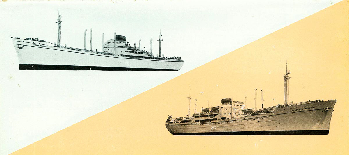
Kapitän Diederichsen (ex-Sebastiano Venier II); cargo motor ship; German
Built: 3rd January 1944
Sunk: 29th February 1944 (naval artillery attack by French light cruiser)
Dimensions: l=134.11 m, w=18.44 m, h=11.84 m, 6,394 tonnes
Coordinates: 44.36636° N, 14.47808° E
Location: NW of the island of Premuda
Access: 1/5 access is solely by boat (the location is in the open sea)
Visibility: 4/5 mostly good
Current: 2/5 occasionally very strong
Flora and fauna: 4/5 varied life on and around the wreck, occasionally specimens of larger fish and crabs
HISTORY:
The Germans allocated to the Aegean Sea a greater part of about 200,000 GRT of shipping capacity that was sequestered in the Adriatic in the autumn of 1943, but the losses due to Allied supremacy in the air were so great that they constantly lacked new ships.
Therefore the commanding admiral in the Adriatic received an order on 12th February 1944 to “…immediately and urgently send two merchant ships to the Aegean Sea.” In the following days the ships were rapidly prepared for the operation. The greatest problem was the lack of air protection, because the German Luftwaffe did not have at its disposal a sufficient number of fighter aircraft in this area. It was decided that the operation should start upon the worst possible weather conditions so that the danger from Allied aircraft would be minimal.
On 28th February Kapitän Diederichsen accepted the load of coal in Raša, and the next morning with the escort of one minesweeper it sailed for Pula, where the corvettes and torpedo boats were waiting for it. Although the headquarters of the admiralty of the Adriatic received many reports that British Spitfire fighters despite bad weather – rain and wind – were patrolling the wide area around the Adriatic ports during the day, the information was not paid much attention.
In the early afternoon of the same day from two French light cruisers set off from the Italian port of Manfredonia towards the Dalmatian coast. The British communications tapping service had already had earlier information that the German convoy would sail to Greece and so decided to intercept and destroy it. At around 2135 hrs. the French ships established radar contact with the enemy convoy at a distance of 17,000 metres. When at 2144 hrs. the distance dropped to 8,000 metres, the French ships opened fire. The German ships immediately returned fire, but after just four minutes, the Kapitän Diederichsen was hit and not long after that, so was the TA 37 Gladio. The cruisers extended out towards the northwest and came across the corvette UJ 201 Egeria which was hit many times, after which it exploded and sank. The French ships ceased firing and were soon out of sight.
The German convoy was in a critical condition. The TA 37 Gladio was heavily damaged, with one engine out of action and also in flames. The TA 36 Stella Polare and UJ 205 Colubrina took the crew from the burning Kapitän Diederichsen and headed back to Pula. The torpedo boat TA 37 somehow managed to sail under its own power to about 10 nautical miles south of Pula, where it stopped due to water flooding into two below deck areas and the engine room, and was finally towed into Pula. An attempt at towing the burning Kapitän Diederichsen failed and so at 1145 hrs. it sank from the damage it had received. According to German data, the position of the sinking was 44˚ 19' N and 14˚ 21' E, and the ship sank to a depth of 62 metres and was lying on its right side on the bottom.
This carefully planned and prepared operation ingloriously ended, which resulted in a lack of necessary ships arriving in the Aegean Sea, and therefore for the Germans the already serious situation in Greece considerably worsened.
WRECK CONDITION AND DIVING:
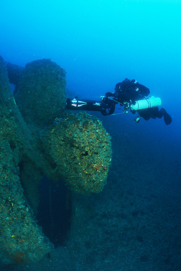
The position of the wreck is close to the border of Croatia’s territorial waters, some 500 metres inside the Croatian area. Occasionally strong currents can be encountered which can hinder us in finding the wreck, and so it is necessary to be well prepared. After finding the wreck with the help of GPS equipment and an echo sounder, it is best to correctly mark the position of the wreck with a buoy, a thin rope and a weight. The highest part of the wreck is slightly shallower at 50 metres, and the depth at the bottom is 62 metres. The first thirty metres of sea can be very clear, but with the increase in depth visibility decreases. Only when passing forty metres does a simple shape of a wreck begin to appear.
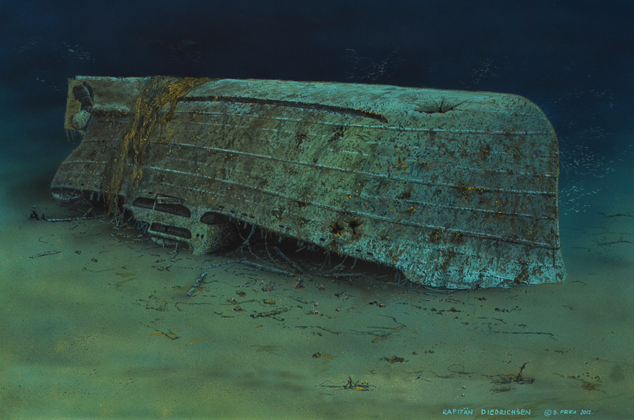
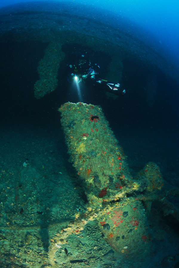
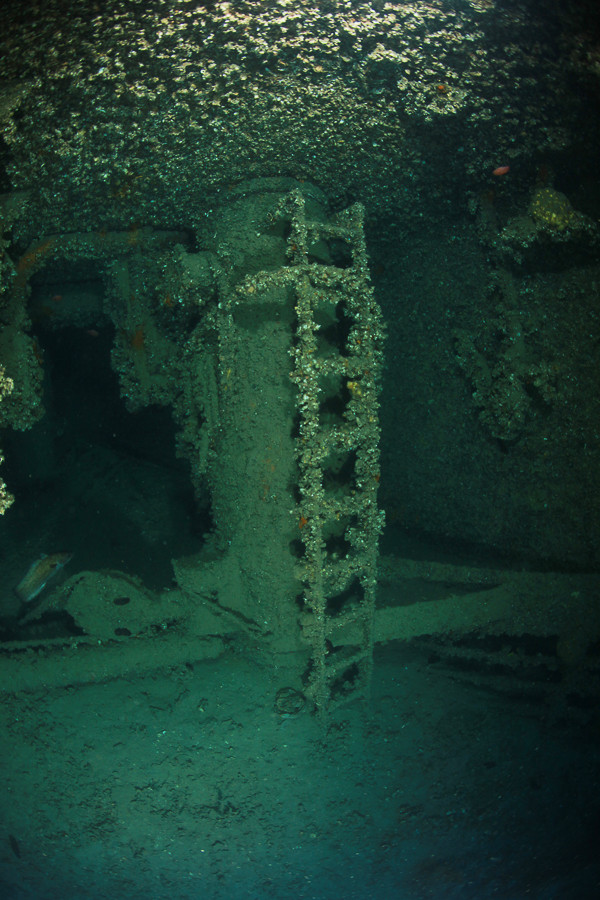
The ship’s hull, which is overturned at about 45 degrees, lies roughly in an east-west direction, with the bow of the wreck facing the east. The shallowest part is the bilge keel which protrudes perpendicular towards the surface and is located somewhere in the middle of the ship. In the shadow of the deck there rest large groupers which are everywhere and who, accustomed to divers, allows to get very close. The lateral side of the superstructure has the characteristic open upper decks (corridors) which are unique to this class of ship that helped with identifying the Diederichsen. On the superstructure is a series of rectangular windows, all of which are open. The corridors are well-preserved although there is some silt, so care should be taken when moving with flippers.
The keel of the ship was quite thick and at this point rounded exactly the same as in the photograph of the ship’s launch. The forward cargo holds are empty, because the coal which the ship was transporting had burnt in the fire. On the underwater side of the hull at the bow is a large hole, which could not have been made by the missiles, and so its creation can only be attributed to the explosion of a sea mine, that could have occurred whilst the ship sailed out of control for hours after the battle. Through this hole one can from the top side enter into the forward cargo hold, pass all the way until the superstructure and then under the edge of the deck emerge from the cargo hold. All around the ship are scattered steel barrels with fuel, which was one part of the ship’s cargo.
The aft section of the ship is also very impressive, with a large four-bladed propeller and an equally large rudder which are partially wrapped in fishing nets. We can enter the rear cargo holds if we dive under the edge of the deck which is some 3-4 metres above the bottom.
Note: Due to the depths, as well as the distance from the land, the visit and exploration of this wreck is not simple so it requires good preparation and a reliable boat. Due to the size of the wreck it is ideal for exploration with rebreathers which enable a significantly longer stay at the wreck without the problems with the quantities of mixtures for breathing, whilst a tour of one dive using open circuit breathing apparatus is only possible with the use of underwater scooters.
The description and illustrations are a courtesy of Danijel Frka and Jasen Mesić. Buy the whole book here: https://shop.naklada-val.hr/product_info.php?products_id=561
Built: 3rd January 1944
Sunk: 29th February 1944 (naval artillery attack by French light cruiser)
Dimensions: l=134.11 m, w=18.44 m, h=11.84 m, 6,394 tonnes
Coordinates: 44.36636° N, 14.47808° E
Location: NW of the island of Premuda
Access: 1/5 access is solely by boat (the location is in the open sea)
Visibility: 4/5 mostly good
Current: 2/5 occasionally very strong
Flora and fauna: 4/5 varied life on and around the wreck, occasionally specimens of larger fish and crabs
HISTORY:
The Germans allocated to the Aegean Sea a greater part of about 200,000 GRT of shipping capacity that was sequestered in the Adriatic in the autumn of 1943, but the losses due to Allied supremacy in the air were so great that they constantly lacked new ships.
Therefore the commanding admiral in the Adriatic received an order on 12th February 1944 to “…immediately and urgently send two merchant ships to the Aegean Sea.” In the following days the ships were rapidly prepared for the operation. The greatest problem was the lack of air protection, because the German Luftwaffe did not have at its disposal a sufficient number of fighter aircraft in this area. It was decided that the operation should start upon the worst possible weather conditions so that the danger from Allied aircraft would be minimal.
On 28th February Kapitän Diederichsen accepted the load of coal in Raša, and the next morning with the escort of one minesweeper it sailed for Pula, where the corvettes and torpedo boats were waiting for it. Although the headquarters of the admiralty of the Adriatic received many reports that British Spitfire fighters despite bad weather – rain and wind – were patrolling the wide area around the Adriatic ports during the day, the information was not paid much attention.
In the early afternoon of the same day from two French light cruisers set off from the Italian port of Manfredonia towards the Dalmatian coast. The British communications tapping service had already had earlier information that the German convoy would sail to Greece and so decided to intercept and destroy it. At around 2135 hrs. the French ships established radar contact with the enemy convoy at a distance of 17,000 metres. When at 2144 hrs. the distance dropped to 8,000 metres, the French ships opened fire. The German ships immediately returned fire, but after just four minutes, the Kapitän Diederichsen was hit and not long after that, so was the TA 37 Gladio. The cruisers extended out towards the northwest and came across the corvette UJ 201 Egeria which was hit many times, after which it exploded and sank. The French ships ceased firing and were soon out of sight.
The German convoy was in a critical condition. The TA 37 Gladio was heavily damaged, with one engine out of action and also in flames. The TA 36 Stella Polare and UJ 205 Colubrina took the crew from the burning Kapitän Diederichsen and headed back to Pula. The torpedo boat TA 37 somehow managed to sail under its own power to about 10 nautical miles south of Pula, where it stopped due to water flooding into two below deck areas and the engine room, and was finally towed into Pula. An attempt at towing the burning Kapitän Diederichsen failed and so at 1145 hrs. it sank from the damage it had received. According to German data, the position of the sinking was 44˚ 19' N and 14˚ 21' E, and the ship sank to a depth of 62 metres and was lying on its right side on the bottom.
This carefully planned and prepared operation ingloriously ended, which resulted in a lack of necessary ships arriving in the Aegean Sea, and therefore for the Germans the already serious situation in Greece considerably worsened.
WRECK CONDITION AND DIVING:
The position of the wreck is close to the border of Croatia’s territorial waters, some 500 metres inside the Croatian area. Occasionally strong currents can be encountered which can hinder us in finding the wreck, and so it is necessary to be well prepared. After finding the wreck with the help of GPS equipment and an echo sounder, it is best to correctly mark the position of the wreck with a buoy, a thin rope and a weight. The highest part of the wreck is slightly shallower at 50 metres, and the depth at the bottom is 62 metres. The first thirty metres of sea can be very clear, but with the increase in depth visibility decreases. Only when passing forty metres does a simple shape of a wreck begin to appear.
The ship’s hull, which is overturned at about 45 degrees, lies roughly in an east-west direction, with the bow of the wreck facing the east. The shallowest part is the bilge keel which protrudes perpendicular towards the surface and is located somewhere in the middle of the ship. In the shadow of the deck there rest large groupers which are everywhere and who, accustomed to divers, allows to get very close. The lateral side of the superstructure has the characteristic open upper decks (corridors) which are unique to this class of ship that helped with identifying the Diederichsen. On the superstructure is a series of rectangular windows, all of which are open. The corridors are well-preserved although there is some silt, so care should be taken when moving with flippers.
The keel of the ship was quite thick and at this point rounded exactly the same as in the photograph of the ship’s launch. The forward cargo holds are empty, because the coal which the ship was transporting had burnt in the fire. On the underwater side of the hull at the bow is a large hole, which could not have been made by the missiles, and so its creation can only be attributed to the explosion of a sea mine, that could have occurred whilst the ship sailed out of control for hours after the battle. Through this hole one can from the top side enter into the forward cargo hold, pass all the way until the superstructure and then under the edge of the deck emerge from the cargo hold. All around the ship are scattered steel barrels with fuel, which was one part of the ship’s cargo.
The aft section of the ship is also very impressive, with a large four-bladed propeller and an equally large rudder which are partially wrapped in fishing nets. We can enter the rear cargo holds if we dive under the edge of the deck which is some 3-4 metres above the bottom.
Note: Due to the depths, as well as the distance from the land, the visit and exploration of this wreck is not simple so it requires good preparation and a reliable boat. Due to the size of the wreck it is ideal for exploration with rebreathers which enable a significantly longer stay at the wreck without the problems with the quantities of mixtures for breathing, whilst a tour of one dive using open circuit breathing apparatus is only possible with the use of underwater scooters.
The description and illustrations are a courtesy of Danijel Frka and Jasen Mesić. Buy the whole book here: https://shop.naklada-val.hr/product_info.php?products_id=561


INVESTMENTS
 H2O Globe BETA
was successfully backed by an amazing group of diving lovers from all around the world!
