


HMS CORIOLANUS
DEPTH: 11 - 25 m
SKILL: All
Coriolanus, Shakespeare class; Minesweeper; Great Britain, Royal Navy
Launched: 20th October 1940
Sunk: 5th May 1945 (underwater mine)
Dimensions: l=49.99 m, w=8.43 m, h=3.38 m, displacement 545 t (standard), 770 t (deep load)
Coordinates: 45.32065° N, 13.39010˚ E
Location: W of Novigrad, Istria
Access: 2/5 access is solely by boat (the location is in the open sea)
Visibility: 2/5 in summer low, in winter considerably better
Current : 3/5 mostly weak, but due to the open sea occasionally moderate
Flora and fauna: 4/5 varied life on and around the wreck, occasionally specimens of large fish
HISTORY:
To prevent the penetration of Allied warships towards the northern Adriatic, the Germans had during the previous two years of the war laid several thousands of various kinds of sea mines. The mined obstacles had blocked all canals and approaches to the ports, and many minefields were also laid in the open sea off the east coast of Istria. In order to establish necessary maritime traffic along the coast, British minesweepers began the dangerous job of clearing the mines and creating a navigable waterway through the minefields. The clearing of anchored mines was done with floats, which the ship dragged behind it via a steel cable. When the steel cable which the float was dragged by hooked an anchored mine, it would slide all the way up to the float where a special chisel would cut it free. Then the mine, freed from is anchor, would emerge at the surface from where the minesweeper would then destroy it with shelling from a safe distance.
The British minesweeper Coriolanus of the Trawler type belonged to the Shakespeare class of which 12 were built according to a programme from 1939. The Coriolanus was built in the shipyard of Amos & Smith in Cochrane, and was launched into the sea on 20th October 1940. It entered the Royal Navy’s fleet on 6th February 1941 when its prow received the marking “T 140”.
On 5th May 1945 the Coriolanus came across a mine whilst clearing minefields west of Novigrad. The explosion which followed made a large hole in the hull of the ship high in the forward hold, whereupon which the ship very quickly sank. Details of this maritime accident are unknown, but according to the condition of the ship it can be concluded that there were certainly victims.
WRECK CONDITION AND DIVING:
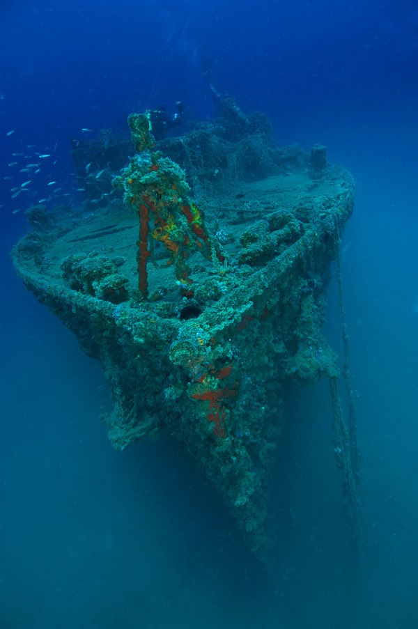
The ship lies upright on a flat sandy bottom at a depth of 25 metres. The shallowest parts of the ship are at 11 metres depth and sometimes with a calm sea they can also be seen from the surface.
The location of the sinking is several miles away from the coast, and so therefore it can only be found with help of familiar landmarks ashore or with GPS equipment. For this reason, and also because the wreck of the Coriolanus is in a protected zone, diving is carried out via authorised diving centres which know the region well and can easily find the location of the wreck.
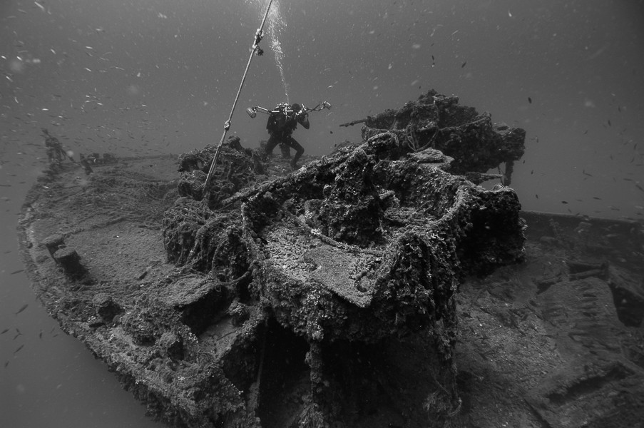
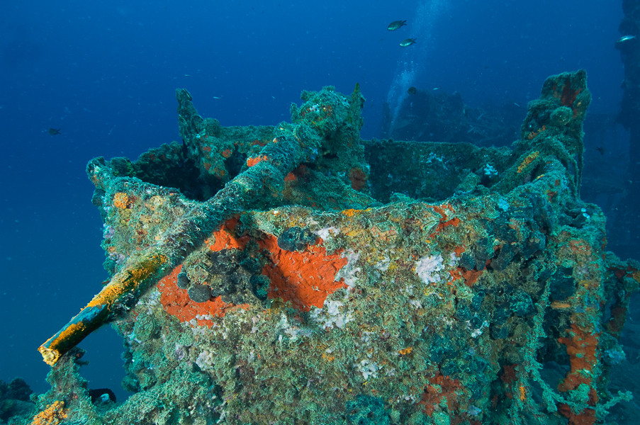
Due to the many particles which float in the sea, shallow depths and water temperature, visibility in the summer months is mostly poor. Diving conditions are better in the winter months when the visibility is considerably better. After just several metres into the dive the simple profile of the ship’s hull can be made out on the bottom. The ship is in one piece and its hull is intact. The bow part is well-preserved and on its forecastle the anchor windlass and anchor chains, which are still in situ, can be seen. The panelling of the main deck between the forecastle and bridge is completely torn from the explosion. Through it can be seen a large hole in the right side in the place where the mine exploded.
The upper deck is intact and on it are the remains of the bridge. The bridge has been, crushed by the base and cupola of the direction-finder which fell onto it, probably following the explosion of the mine, however there could be a another scenario. That is to say, as the ship sank in shallow depths, its wreck presented a danger to navigation and so it is possible that after the war the taller parts of the ship were mined (the mast and bridge), so as not to disturb the navigation of ships.
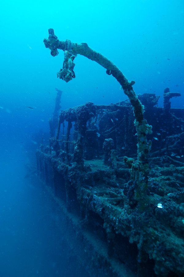
Behind these remains are found the circular hole around which is the crumpled panelling of the funnel. Diving further towards the aft we come to a cone-shaped construction. It is the tower of a derrick which lies damaged on the upper deck. At the end of the stern can be seen a large anchor windlass with coiled up steel cables which would have been used for towing the floats, the main equipment for demining. The Coriolanus, in fact, possessed two floats which it towed behind itself. On the aft deck of the Coriolanus there are no floats which means that the ship perished whilst demining. It is possible to enter the side passages which are found on both sides of the superstructure, below the upper deck. Here can be seen various entrances to below decks, but due to the muddiness and narrow passages it is not advisable to enter these spaces. Shoals of fish constantly gather here, most frequently whiting, but large forkbeards can also be found, common inhabitants of wrecks.
The Coriolanus is not a large ship and due to its shallow depth it is accessible to all divers. Although in poorer visibility there is some danger that a diver can get lost. The shallow depth allows enough time to stay on the ship so that one can view all of its details. For less experienced divers it is an excellent introduction to wreck diving, and for fans of warships it is an opportunity to get close to a detailed view of a ship of this type.
Note: The wreck of the Coriolanus is located in a protected zone which means that diving on it is not allowed without an authorised diving centre.
The description and illustrations are a curtesy of Danijel Frka and Jasen Mesić. Buy the whole book here: https://shop.naklada-val.hr/product_info.php?products_id=561
Launched: 20th October 1940
Sunk: 5th May 1945 (underwater mine)
Dimensions: l=49.99 m, w=8.43 m, h=3.38 m, displacement 545 t (standard), 770 t (deep load)
Coordinates: 45.32065° N, 13.39010˚ E
Location: W of Novigrad, Istria
Access: 2/5 access is solely by boat (the location is in the open sea)
Visibility: 2/5 in summer low, in winter considerably better
Current : 3/5 mostly weak, but due to the open sea occasionally moderate
Flora and fauna: 4/5 varied life on and around the wreck, occasionally specimens of large fish
HISTORY:
To prevent the penetration of Allied warships towards the northern Adriatic, the Germans had during the previous two years of the war laid several thousands of various kinds of sea mines. The mined obstacles had blocked all canals and approaches to the ports, and many minefields were also laid in the open sea off the east coast of Istria. In order to establish necessary maritime traffic along the coast, British minesweepers began the dangerous job of clearing the mines and creating a navigable waterway through the minefields. The clearing of anchored mines was done with floats, which the ship dragged behind it via a steel cable. When the steel cable which the float was dragged by hooked an anchored mine, it would slide all the way up to the float where a special chisel would cut it free. Then the mine, freed from is anchor, would emerge at the surface from where the minesweeper would then destroy it with shelling from a safe distance.
The British minesweeper Coriolanus of the Trawler type belonged to the Shakespeare class of which 12 were built according to a programme from 1939. The Coriolanus was built in the shipyard of Amos & Smith in Cochrane, and was launched into the sea on 20th October 1940. It entered the Royal Navy’s fleet on 6th February 1941 when its prow received the marking “T 140”.
On 5th May 1945 the Coriolanus came across a mine whilst clearing minefields west of Novigrad. The explosion which followed made a large hole in the hull of the ship high in the forward hold, whereupon which the ship very quickly sank. Details of this maritime accident are unknown, but according to the condition of the ship it can be concluded that there were certainly victims.
WRECK CONDITION AND DIVING:
The ship lies upright on a flat sandy bottom at a depth of 25 metres. The shallowest parts of the ship are at 11 metres depth and sometimes with a calm sea they can also be seen from the surface.
The location of the sinking is several miles away from the coast, and so therefore it can only be found with help of familiar landmarks ashore or with GPS equipment. For this reason, and also because the wreck of the Coriolanus is in a protected zone, diving is carried out via authorised diving centres which know the region well and can easily find the location of the wreck.
Due to the many particles which float in the sea, shallow depths and water temperature, visibility in the summer months is mostly poor. Diving conditions are better in the winter months when the visibility is considerably better. After just several metres into the dive the simple profile of the ship’s hull can be made out on the bottom. The ship is in one piece and its hull is intact. The bow part is well-preserved and on its forecastle the anchor windlass and anchor chains, which are still in situ, can be seen. The panelling of the main deck between the forecastle and bridge is completely torn from the explosion. Through it can be seen a large hole in the right side in the place where the mine exploded.
The upper deck is intact and on it are the remains of the bridge. The bridge has been, crushed by the base and cupola of the direction-finder which fell onto it, probably following the explosion of the mine, however there could be a another scenario. That is to say, as the ship sank in shallow depths, its wreck presented a danger to navigation and so it is possible that after the war the taller parts of the ship were mined (the mast and bridge), so as not to disturb the navigation of ships.
Behind these remains are found the circular hole around which is the crumpled panelling of the funnel. Diving further towards the aft we come to a cone-shaped construction. It is the tower of a derrick which lies damaged on the upper deck. At the end of the stern can be seen a large anchor windlass with coiled up steel cables which would have been used for towing the floats, the main equipment for demining. The Coriolanus, in fact, possessed two floats which it towed behind itself. On the aft deck of the Coriolanus there are no floats which means that the ship perished whilst demining. It is possible to enter the side passages which are found on both sides of the superstructure, below the upper deck. Here can be seen various entrances to below decks, but due to the muddiness and narrow passages it is not advisable to enter these spaces. Shoals of fish constantly gather here, most frequently whiting, but large forkbeards can also be found, common inhabitants of wrecks.
The Coriolanus is not a large ship and due to its shallow depth it is accessible to all divers. Although in poorer visibility there is some danger that a diver can get lost. The shallow depth allows enough time to stay on the ship so that one can view all of its details. For less experienced divers it is an excellent introduction to wreck diving, and for fans of warships it is an opportunity to get close to a detailed view of a ship of this type.
Note: The wreck of the Coriolanus is located in a protected zone which means that diving on it is not allowed without an authorised diving centre.
The description and illustrations are a curtesy of Danijel Frka and Jasen Mesić. Buy the whole book here: https://shop.naklada-val.hr/product_info.php?products_id=561


INVESTMENTS
 H2O Globe BETA
was successfully backed by an amazing group of diving lovers from all around the world!
