


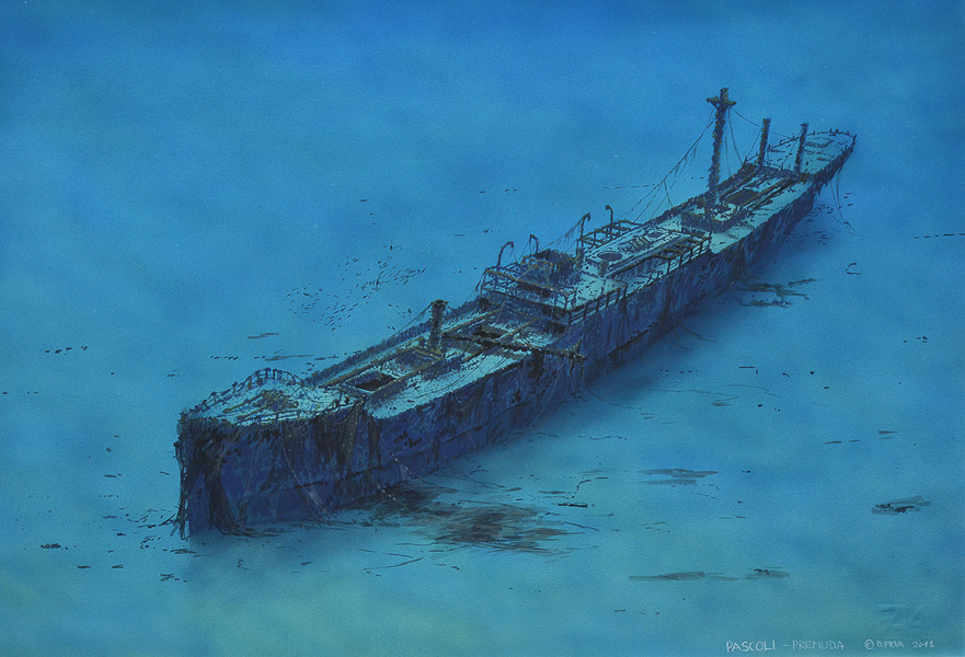

PASCOLI
DEPTH: 40 - 61 m
SKILL: Expert
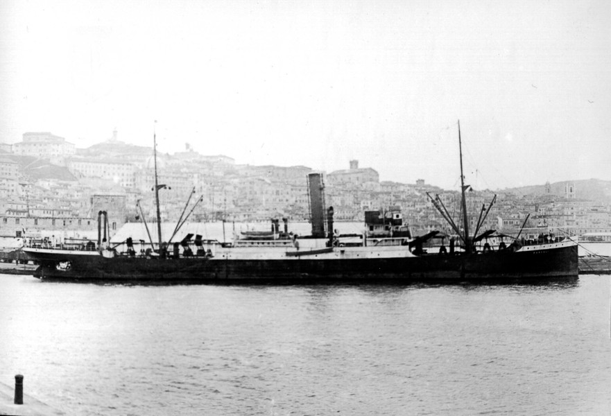
Pascoli (ex-Szeged); merchant steamship; Italy
Built: 1902, W. Dobson & Co. Shipyard, Newcastle, Great Britain
Sunk: 7th May 1941 (mine)
Dimensions: l=99 m, w=13.5 m, h=6.42 m
Coordinates: 44.32119° N, 14.32933° E
Location: south of the island of Susak
Access: 1/5 access is possible only by boat
Visibility: 4-5/5 mostly very good
Current: 4/5 mostly weak
Flora and fauna: 5/5 varied life on and around the wreck, specimens of large fish
HISTORY:
The waters west of the island of Premuda were the scene of many conflicts in both world wars. On 10th June 1918 the Austro-Hungarian battleship Szent Istvan was torpedoed and sunk, and 26 years later, in the Second World War, many more ships perished there.
The identity of this ship remained a secret until we browsed in detail the Italian book ‘Navi Mercantili Perdute nella Seconda Guerra Mondiale’ where we found information about the steamship Pascoli (ex-Szeged) which was sailing from Italy towards Susak and hit a mine and sank on 7th May 1941. The exact details of the sinking are not known, and there isn’t even a description of the event. The damage to the ship’s hull at the stern indicates that the mine’s explosion damaged the hull in the last section and that the ship sank stern first and lay upright on the bottom.
WRECK CONDITION AND DIVING:
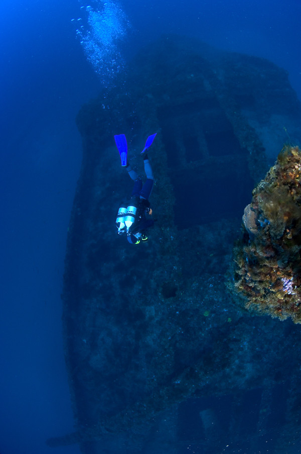
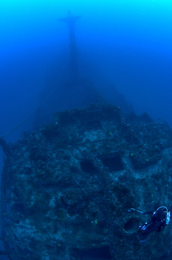
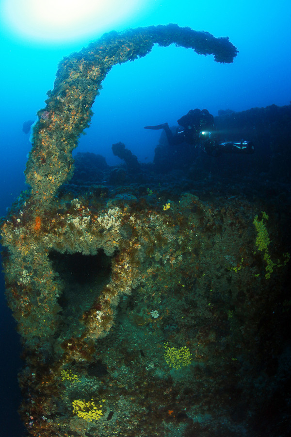
It is best to start the dive descending to the superstructure and the remains of the bridge. The depth is 48 metres, whilst the top of the mast at 40 metres is the shallowest part of the wreck. Only the walls and front windows remain of the bridge. All the objects on the decks are very overgrown with sea vegetation, so most of them cannot be recognised under the thick layers of sponges and corals. A shoal of large dentex loiter around the superstructure. Always on the alert, they keep a respectful distance from us, and when we turn towards them they slowly swim away into the darkness of the forward cargo hold. Only one third of the foremast remains upright, whilst the rest of it lies over the open forward cargo hold. At the bow is the anchoring gear with windlasses, from which two thick chains lead to openings on the deck and further on towards the anchors. Both anchors are in place, which means that the ship was in motion at the moment when it was damaged. On the deck there was no sign of any explosion, besides the foremast being broken about half way up. On the bow there are the remains of many fishing nets, which is a sign that the wreck has long been known to fishermen. Travelling through the forward cargo hold we found nothing in them except thick layers of silt. On the deck we found a ceramic plate with the mark of the factory which produced it. I photographed the mark, hoping that it would help us in recognising and identifying the wreck. A little further on the superstructure the skylight above the engine room could be seen, and beyond that the superstructure ended and rear cargo hold could be made out. At that time we were already near the end of planned time for staying on the wreck, so slowly along the mizzenmast we turned towards the surface.
Due to its distance from the coast this wreck is wrapped in a shroud of obscurity, and just in the last recent years has it been visited by a few expeditions of technical divers. Due to its size, its condition of preservation and the wealth of fish species the wreck of the steamship Pascoli is certainly one of several of the most beautiful wrecks in the Adriatic.
The description and illustrations are a courtesy of Danijel Frka and Jasen Mesić. Buy the whole book here: https://shop.naklada-val.hr/product_info.php?products_id=561
Built: 1902, W. Dobson & Co. Shipyard, Newcastle, Great Britain
Sunk: 7th May 1941 (mine)
Dimensions: l=99 m, w=13.5 m, h=6.42 m
Coordinates: 44.32119° N, 14.32933° E
Location: south of the island of Susak
Access: 1/5 access is possible only by boat
Visibility: 4-5/5 mostly very good
Current: 4/5 mostly weak
Flora and fauna: 5/5 varied life on and around the wreck, specimens of large fish
HISTORY:
The waters west of the island of Premuda were the scene of many conflicts in both world wars. On 10th June 1918 the Austro-Hungarian battleship Szent Istvan was torpedoed and sunk, and 26 years later, in the Second World War, many more ships perished there.
The identity of this ship remained a secret until we browsed in detail the Italian book ‘Navi Mercantili Perdute nella Seconda Guerra Mondiale’ where we found information about the steamship Pascoli (ex-Szeged) which was sailing from Italy towards Susak and hit a mine and sank on 7th May 1941. The exact details of the sinking are not known, and there isn’t even a description of the event. The damage to the ship’s hull at the stern indicates that the mine’s explosion damaged the hull in the last section and that the ship sank stern first and lay upright on the bottom.
WRECK CONDITION AND DIVING:
It is best to start the dive descending to the superstructure and the remains of the bridge. The depth is 48 metres, whilst the top of the mast at 40 metres is the shallowest part of the wreck. Only the walls and front windows remain of the bridge. All the objects on the decks are very overgrown with sea vegetation, so most of them cannot be recognised under the thick layers of sponges and corals. A shoal of large dentex loiter around the superstructure. Always on the alert, they keep a respectful distance from us, and when we turn towards them they slowly swim away into the darkness of the forward cargo hold. Only one third of the foremast remains upright, whilst the rest of it lies over the open forward cargo hold. At the bow is the anchoring gear with windlasses, from which two thick chains lead to openings on the deck and further on towards the anchors. Both anchors are in place, which means that the ship was in motion at the moment when it was damaged. On the deck there was no sign of any explosion, besides the foremast being broken about half way up. On the bow there are the remains of many fishing nets, which is a sign that the wreck has long been known to fishermen. Travelling through the forward cargo hold we found nothing in them except thick layers of silt. On the deck we found a ceramic plate with the mark of the factory which produced it. I photographed the mark, hoping that it would help us in recognising and identifying the wreck. A little further on the superstructure the skylight above the engine room could be seen, and beyond that the superstructure ended and rear cargo hold could be made out. At that time we were already near the end of planned time for staying on the wreck, so slowly along the mizzenmast we turned towards the surface.
Due to its distance from the coast this wreck is wrapped in a shroud of obscurity, and just in the last recent years has it been visited by a few expeditions of technical divers. Due to its size, its condition of preservation and the wealth of fish species the wreck of the steamship Pascoli is certainly one of several of the most beautiful wrecks in the Adriatic.
The description and illustrations are a courtesy of Danijel Frka and Jasen Mesić. Buy the whole book here: https://shop.naklada-val.hr/product_info.php?products_id=561


INVESTMENTS
 H2O Globe BETA
was successfully backed by an amazing group of diving lovers from all around the world!
