


VIS
DEPTH: 45 - 60 m
SKILL: Expert
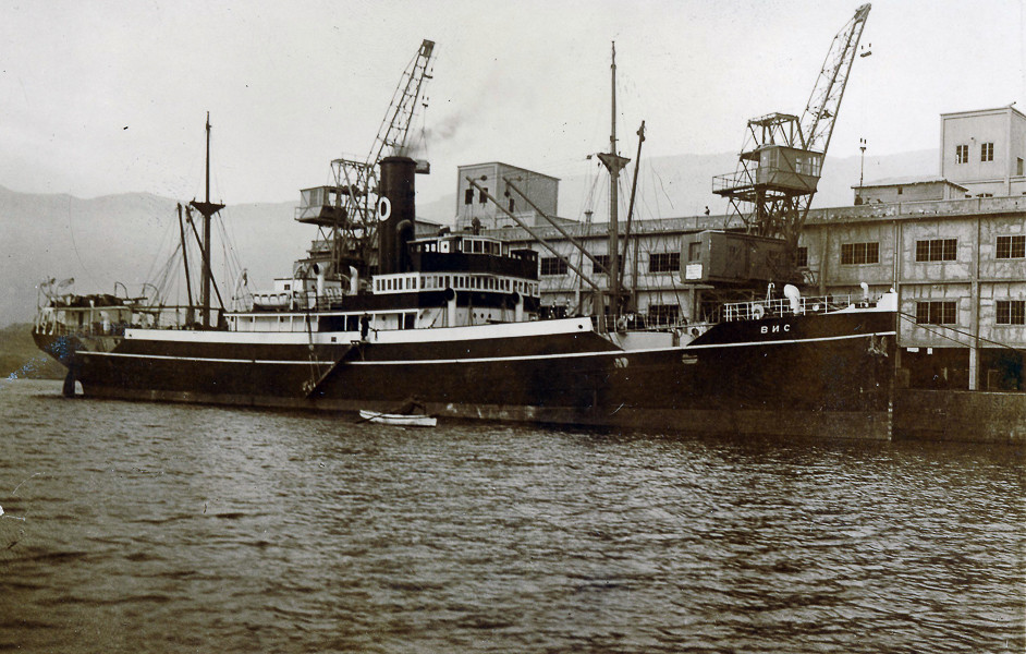
Vis (ex-Renteria); cargo steamship; Yugolsav, Oceania Company, Sušak
Built: 1921 Port of Glasgow, Great Britain
Sunk: 13th February 1946 (mine)
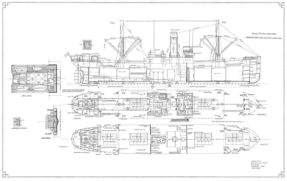
Dimensions: l=79 m, w=12.5 m
Coordinates: 45.12422° N, 14.21740° E
Location: about 400 m E of the Cape of Mašnjak, eastern coast of Istria
Access: 2/5 access is possible only by boat
Visibility: 3-4/5 mostly good, occasionally very good
Current: 4/5 mostly weak
Flora and fauna: 4/5 varied life on and around the wreck
HISTORY:
Built in Great Britain under the name of Renteria in 1921 for the ship owner Fearnley & Eger from Norway. In August 1934 the ship changed ownership – the Yugoslav joint-share shipping company Oceania from Sušak bought it and it gained a new name – Vis. After the outbreak of war in 1939 Vis received the inscription “Yugoslav” and the state flag on its side, so as submarines and warships of the warring sides could identify from a distance that this ship was from a neutral country. However after the occupation of Yugoslavia in April 1941, all Yugoslavian merchant ships which found themselves in British or American ports were requisitioned for the needs of the navy. This was also the fate of the steamship Vis, which was immediately enlisted into the convoys of Allied ships.
By the end of the war the Vis headed across the Atlantic to England, where it unloaded a cargo of wooden building material, and then continued its journey to Oran in North Africa. The ship conducted several more voyages, after which in February 1946 it arrived in Rijeka.
On the morning of 13th February 1946 the Vis embarked for Raša in Istria, where it was to take on a load of coal. Due to the danger of mines, since the central part of Vela Vrata had still not been cleared of minefields, the captain was ordered to stay as close as possible to the Istrian coast, where there existed a corridor cleared of mines. Therefore the Vis sailed closely along the steep coast of Istria, keeping a distance of about 400 m.
At around 0930 hrs. the Vis found itself within reach of the Cape of Mašnjak , the ship shook from a tremendous explosion, and along the right bow railing there rose a large watery column. There was no time to lower the lifeboats, because the ship had already plunged at the bow down to the main deck. Only the rafts which the Allies had placed on sloping ramps along the superstructure of the ship remained, in the case that the ship needed to be abandoned quickly. The ropes which held the life rafts were cut and they slipped into the sea. Not even ten minutes had passed since the explosion, and the Vis, its stern raised high, submerged forever.
WRECK CONDITION AND DIVING:
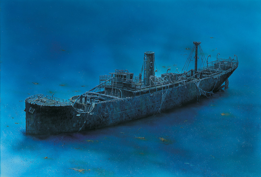
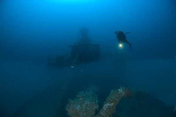
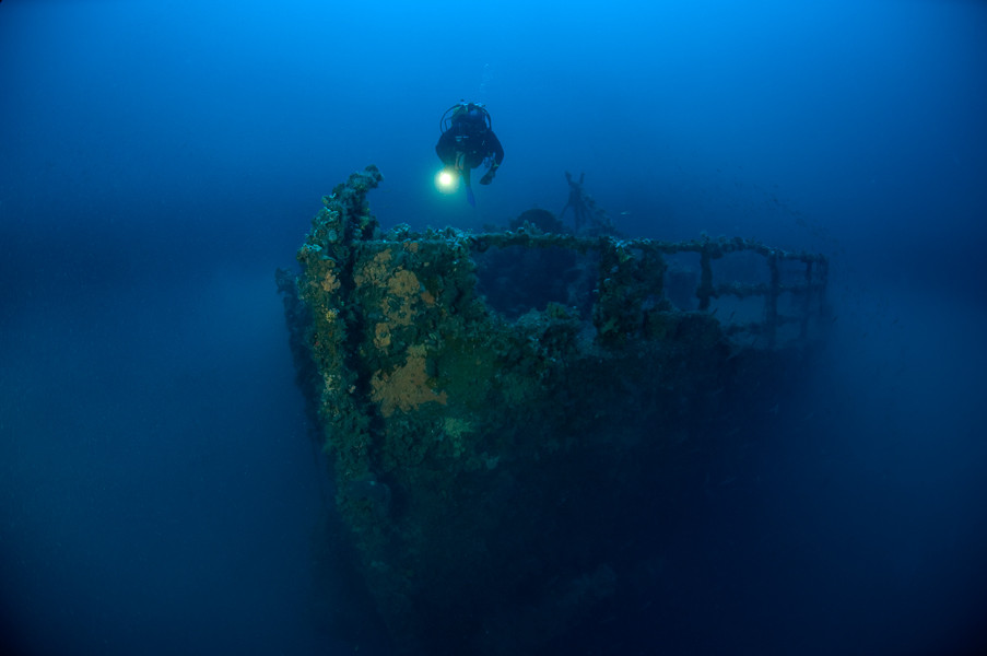
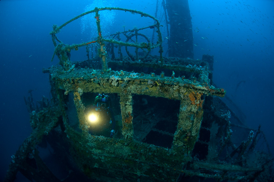
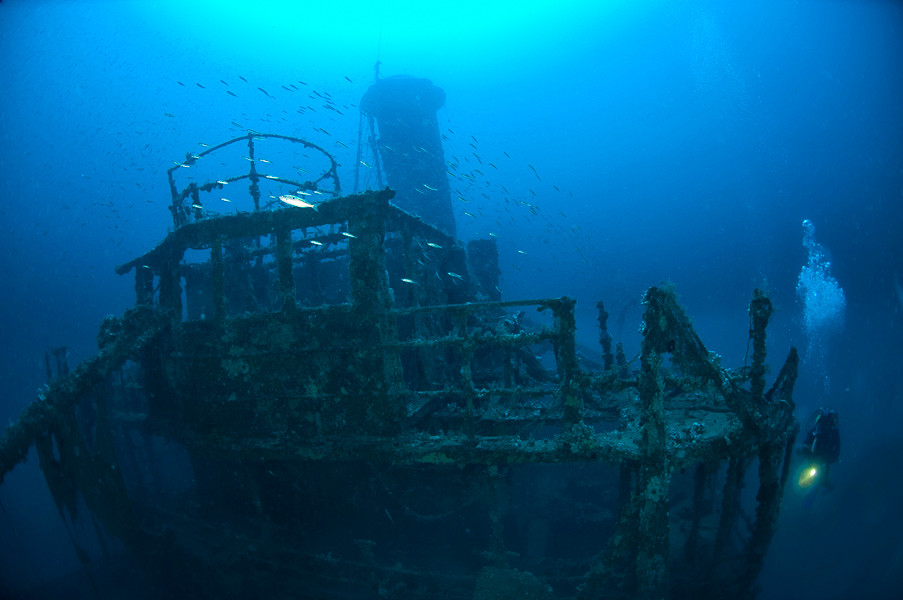
Although it is only about 400 m away from the coast at the foot of the village of Načinovići, diving on the ship falls under open sea diving. A buoy is not connected to the wreck and so the help of an echo sounder is necessary to locate it. After descending it is usual that in the depths the highest parts of the ship come into view – the funnel. The sides of the funnel are slightly flattened, since during the time of its sinking, the sea it did not enter the ship’s interior, so the sea has pressed on to the exterior of the funnel and so indenting its panelling. Still recognisable, attached to both sides of the funnel was a large plated letter “O” – the mark of the Oceania company. The superstructure of the ship is well-preserved, except that the wooden decks have rotted away so it is possible to descend into the interior without particular problems. On the wings of the bridge the floor is reinforced with circular steel plates. These are reinforcements for anti-aircraft guns which the Vis carried whilst it was used during Allied service. All the external parts of the ship are thickly overgrown with various sea vegetation transforming objects into unrecognisable shapes.
The bow part of the ship is severely damaged. The collapsed mast lies over the hatch of the cargo hold number 2, together with masses of steel weights which spread everywhere during the explosion of the mine. The side of the ship at the level of the front cargo hold was completely torn apart with the explosion and in that place gapes a huge hole the entire height of the side. The deck at the place of the explosion is also torn apart, and its sides are curved upwards. The bracket on which the ship’s bell once hung is empty. The bell long ago became the booty of some of the first visitors. Both anchors are still in situ in the bow’s “eyes”.
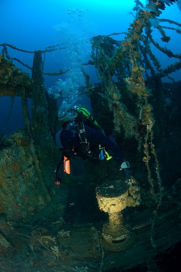
Behind the funnel is the skylight of the engine room, the covers of which are partially open. Through them in a strong beam of light the shapes of the steam machine become visible. Swimming towards the aft section we pass along one smaller structure of the superstructure, and then in front of us appears the hatch of cargo hold number 3. On the left side of the bulkhead which divides the hold from the engine room is located a fastened reserve propeller.
Dropping down to the bottom of the stern of the ship, we enter a murky layer of water which is almost always found 1-2 metres above the seabed. The propeller and rudder are partially buried in the silt and are barely visible. Along the side of the ship on the seabed are the remains of the wooden lifeboats. The superstructure is the most interesting part of the ship and around it can always be seen large shoals of fish, mostly the small picarel and the somewhat larger whiting. Conger eels are not uncommon, especially in the interior of the ship.
The description and illustrations are a courtesy of Danijel Frka and Jasen Mesić. Buy the whole book here: https://shop.naklada-val.hr/product_info.php?products_id=561
Built: 1921 Port of Glasgow, Great Britain
Sunk: 13th February 1946 (mine)
Dimensions: l=79 m, w=12.5 m
Coordinates: 45.12422° N, 14.21740° E
Location: about 400 m E of the Cape of Mašnjak, eastern coast of Istria
Access: 2/5 access is possible only by boat
Visibility: 3-4/5 mostly good, occasionally very good
Current: 4/5 mostly weak
Flora and fauna: 4/5 varied life on and around the wreck
HISTORY:
Built in Great Britain under the name of Renteria in 1921 for the ship owner Fearnley & Eger from Norway. In August 1934 the ship changed ownership – the Yugoslav joint-share shipping company Oceania from Sušak bought it and it gained a new name – Vis. After the outbreak of war in 1939 Vis received the inscription “Yugoslav” and the state flag on its side, so as submarines and warships of the warring sides could identify from a distance that this ship was from a neutral country. However after the occupation of Yugoslavia in April 1941, all Yugoslavian merchant ships which found themselves in British or American ports were requisitioned for the needs of the navy. This was also the fate of the steamship Vis, which was immediately enlisted into the convoys of Allied ships.
By the end of the war the Vis headed across the Atlantic to England, where it unloaded a cargo of wooden building material, and then continued its journey to Oran in North Africa. The ship conducted several more voyages, after which in February 1946 it arrived in Rijeka.
On the morning of 13th February 1946 the Vis embarked for Raša in Istria, where it was to take on a load of coal. Due to the danger of mines, since the central part of Vela Vrata had still not been cleared of minefields, the captain was ordered to stay as close as possible to the Istrian coast, where there existed a corridor cleared of mines. Therefore the Vis sailed closely along the steep coast of Istria, keeping a distance of about 400 m.
At around 0930 hrs. the Vis found itself within reach of the Cape of Mašnjak , the ship shook from a tremendous explosion, and along the right bow railing there rose a large watery column. There was no time to lower the lifeboats, because the ship had already plunged at the bow down to the main deck. Only the rafts which the Allies had placed on sloping ramps along the superstructure of the ship remained, in the case that the ship needed to be abandoned quickly. The ropes which held the life rafts were cut and they slipped into the sea. Not even ten minutes had passed since the explosion, and the Vis, its stern raised high, submerged forever.
WRECK CONDITION AND DIVING:
Although it is only about 400 m away from the coast at the foot of the village of Načinovići, diving on the ship falls under open sea diving. A buoy is not connected to the wreck and so the help of an echo sounder is necessary to locate it. After descending it is usual that in the depths the highest parts of the ship come into view – the funnel. The sides of the funnel are slightly flattened, since during the time of its sinking, the sea it did not enter the ship’s interior, so the sea has pressed on to the exterior of the funnel and so indenting its panelling. Still recognisable, attached to both sides of the funnel was a large plated letter “O” – the mark of the Oceania company. The superstructure of the ship is well-preserved, except that the wooden decks have rotted away so it is possible to descend into the interior without particular problems. On the wings of the bridge the floor is reinforced with circular steel plates. These are reinforcements for anti-aircraft guns which the Vis carried whilst it was used during Allied service. All the external parts of the ship are thickly overgrown with various sea vegetation transforming objects into unrecognisable shapes.
The bow part of the ship is severely damaged. The collapsed mast lies over the hatch of the cargo hold number 2, together with masses of steel weights which spread everywhere during the explosion of the mine. The side of the ship at the level of the front cargo hold was completely torn apart with the explosion and in that place gapes a huge hole the entire height of the side. The deck at the place of the explosion is also torn apart, and its sides are curved upwards. The bracket on which the ship’s bell once hung is empty. The bell long ago became the booty of some of the first visitors. Both anchors are still in situ in the bow’s “eyes”.
Behind the funnel is the skylight of the engine room, the covers of which are partially open. Through them in a strong beam of light the shapes of the steam machine become visible. Swimming towards the aft section we pass along one smaller structure of the superstructure, and then in front of us appears the hatch of cargo hold number 3. On the left side of the bulkhead which divides the hold from the engine room is located a fastened reserve propeller.
Dropping down to the bottom of the stern of the ship, we enter a murky layer of water which is almost always found 1-2 metres above the seabed. The propeller and rudder are partially buried in the silt and are barely visible. Along the side of the ship on the seabed are the remains of the wooden lifeboats. The superstructure is the most interesting part of the ship and around it can always be seen large shoals of fish, mostly the small picarel and the somewhat larger whiting. Conger eels are not uncommon, especially in the interior of the ship.
The description and illustrations are a courtesy of Danijel Frka and Jasen Mesić. Buy the whole book here: https://shop.naklada-val.hr/product_info.php?products_id=561
INVESTMENTS
 H2O Globe BETA
was successfully backed by an amazing group of diving lovers from all around the world!
